Europe Vision for an Organization with 60 Regions
Written by Regionen-Europas.workEurotopia - the Division of Europe into Regions
Einleitung
|
The term Eurotopia describes various Visions that deal with possible developments in Europe. Here we address the Vision of the
Dutch businessman and brewer Freddy Heineken from 1992 to divide the European Union into Regions. Within this structure each new Country
would have a similar population, most of them five to ten million inhabitants. In today's European society, various forces are already
working on the creation of smaller states. In almost all European Countries there is currently an urge for decentralization or even
independence.
The advantages of dividing Europe into Regions are obvious. The cooperation of citizens with the
government would be better. Governments could govern more simply and do not need large bureaucracies, while there are already several
federal institutions. Europeans will be able to identify more clearly with a Region.
In the new Europe it would not be possible for a single nation to dominate other Nations.
The land area of the Continent of Europe extends to the Ural Mountains. The 75 Regions according to
description from 1992 cover about 55% of it. In the 75 Regions live about 75% of the population of Europe. With these proportions of
land area and population, we write of a Vision of Europe.
|
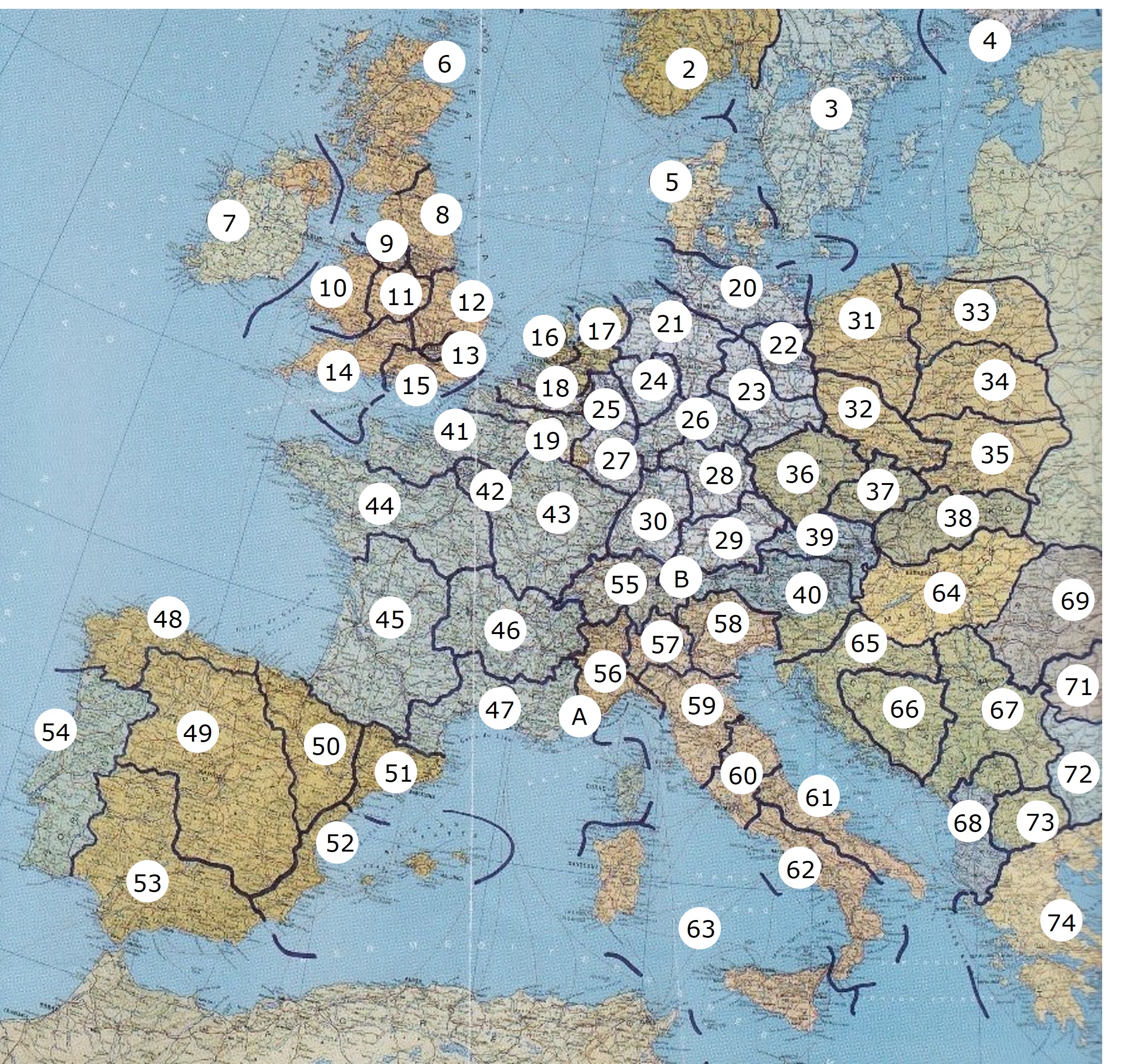
Map of Heineken Eurotopia edited
|
Regions and Capitals
From the 1992 description and edited.
|
27. Rhine-Mosel land, Mainz 28. Franconia, Nuernberg 29. Bavaria, Munich 30. Baden-Wuerttemberg, Stuttgart 31. Poznan, Poznan 32. Silesia, Wroclaw 33. Gdansk, Gdansk 34. Warsaw, Warsaw 35. Galicia, Krakow 36. Bohemia, Prague 37. Moravia, Brno 38. Slovakia, Bratislava 39. Austria, Vienna 40. Noricum, Graz 41. Picardy-Normandy, Rouen 42. Ile-de-France, Paris 43. Burgundy, Nancy 44. Neustria, Nantes 45. Aquitania, Bordeaux 46. Auvergne, Lyon 47. Provence, Marseille 48. Galicia-Asturias, Santiago 49. Castile, Madrid 50. Navarre-Aragon, Bilbao 51. Catalonia, Barcelona 52. Valencia, Valencia
53. Andalusia, Sevilla 54. Portugal, Lisbon 55. Switzerland, Bern 56. Piedmont, Turin 57. Lombardy, Milan 58. Veneto, Venice 59. Tuscany, Bologna 60. Umbria, Rome 61. Apulia, Bari 62. Naples, Naples 63. Sicily, Palermo 64. Hungary, Budapest 65. Croatia, Zagreb 66. Bosnia-Herzegovina, Sarajevo 67. Serbia, Belgrade 68. Albania, Tirana 69. Transylvania, Cluj-Napoca 70. Moldova, Bacau 71. Wallachia, Bucharest 72. Bulgaria, Sofia 73. North Macedonia, Skopje 74. Greece, Athens 75. Cyprus, Nicosia A. Monaco, Monaco B. Lichtenstein, Vaduz |
Ukraine is divided into 24 subareas and and the city of Kiev. One part of the country belongs to Central Europe. The internal conflict has been going on since 2014.
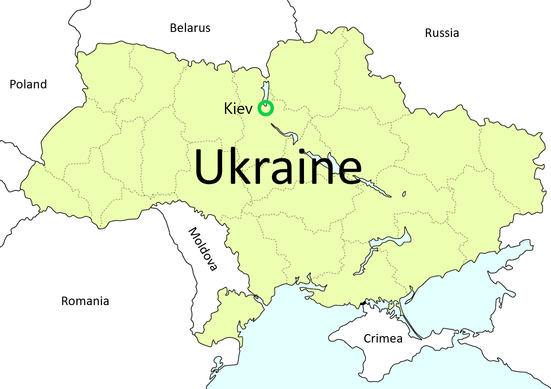
Map Ukraine, Graphic from Landkartenindex.de edited |
The Europe Vision lives
| "Make Europe great again", Abbreviation "MEGA". |
| Europe Vision Sixty Regions as PDF file Download PDF |
| The original text is written in ∗ German. This is a translation. |
| Legend: ∗ With one click you get to the corresponding website. |
| Last update: April 9, 2025 |
Freddy Heineken
The United States of Europe, A Eurotopia
Regions of Europe
Euroregion
With 402,762 inhabitants (as of 31 December 2016)[5], the city of Zurich is the largest city in Switzerland and has a statistical population density of 4,384 inhabitants per square kilometre. The city of Zurich announces the number of residents as of May 2017 according to the concept of economic residence (also includes weekly residents, asylum seekers, refugees with temporary admission) with 419,920 persons.6] With 32.1 percent (31 December 2016)[7], Zurich has an above-average proportion of foreigners (registered population without Swiss citizenship law). The surrounding area is densely populated, with about 1.3 million people living in the conurbation of Zurich[8] and about 1.83 million in the metropolitan region of Zurich[9] The district of Zurich is identical to the urban area.
The city is located in the Swiss midlands, on the Limmat at the outflow of Lake Zurich. The city of Zurich, which emerged from the base Turicum, became a free imperial city in 1262 and a member of the Swiss Confederation in 1351. The city of the reformer Huldrych Zwingli experienced its rise to the present economic metropolis of Switzerland in the industrial age. In 2014, Zurich was awarded the honorary title "European City of Reformation" by the Community of Protestant Churches in Europe.
With its main station, the largest railway station in Switzerland, and the airport, the city of Zurich is a continental traffic junction. Thanks to the large local banks (including UBS and Credit Suisse) and insurance companies (Zurich Insurance Group and Swiss Re), it is an international financial centre and the largest financial centre in Switzerland, followed by Geneva and Lugano. The city is also home to Switzerland's two largest universities, the Swiss Federal Institute of Technology in Zurich and the University of Zurich. Despite its comparatively small population, Zurich is therefore considered one of the world's cities. An above-average number of media companies, including Swiss Radio and Television, are based here. With its location on Lake Zurich, its well-preserved medieval old town and a wide range of cultural activities and nightlife, it is also a centre of tourism.
Zurich lies at 408 m above sea level at the lower (northern) end of Lake Zurich in the valley of the Limmat and in the lower valley of the Sihl, embedded between the hills of Uetliberg in the west and Zurichberg in the east. The Limmat rises from the lake, while the Sihl, which flows west of the lake, flows into the Limmat near old town of zurich at Platzspitz. The old town extends on both sides of the Limmat, which initially flows northwards and then gradually turns west in an arc. The former city did not reach as far as the Sihl, but had as a western boundary the Schanzengraben built in the 17th and 18th centuries. At that time, part of the water was drained from the lake and returned to the Limmat in a ditch outside the bastions and bastions.